
WeRobotics Partners with Elevate Africa UAS Summit 2024
April 30, 2024
WeRobotics is proud to be partnering with the Elevate Africa Summit to be held in Nairobi, Kenya in June 2024.
December 4th, 2023

On November 15th, 2023, WeRobotics and the Flying Labs Network joined the rest of the tech world in celebrating GIS Day. First marked in 1999 and celebrated every third Wednesday of November, it is a time to celebrate the power of geospatial technology and its impact on our world.
Geographic Information Systems (GIS) combine maps with data, allowing us to visualize, analyze, and understand complex real-world problems. We use it in various sectors, from urban planning and disaster management to environmental conservation and public health. At the heart of GIS technology is identifying patterns and using them to make sense of the world around us.
GIS Day 2023 was themed around "Celebrating the GIS Professional," and we should honor the experts that make up the Flying Labs Network. Guided by their commitment to social good, local expertise, and resourceful problem-solving, these remarkable professionals work hard every day to use technologies like GIS to empower their local communities, address pressing social and environmental challenges, and create meaningful change in various parts of Africa, Latin America, Asia, and beyond.
And what better way to celebrate them than to showcase their work and let it speak for itself? Here are only a few examples of the inspiring work that has been done by the Flying Labs in the recent past using GIS technology.
Agriculture is a crucial industry in many parts of the world. Various Flying Labs have used GIS technology to revolutionize crop monitoring. For instance, Uganda Flying Labs applied robotics technology to help coffee farmers spot crop health problems and ensure high yields.
Drones equipped with GIS tools enable farmers to monitor crop health and detect issues such as pests and diseases. Detailed maps help farmers take targeted actions, optimize resource usage, and improve crop yields. By doing so, they are helping local farmers and contributing to food security and sustainable agriculture.
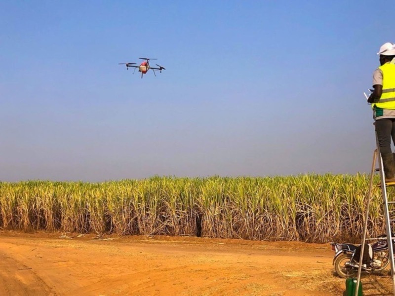 Crop spraying using a drone
Flying Labs are on the front lines of forest conservation in various countries. They use drones and GIS technology to map and monitor forests, helping identify illegal logging and deforestation. This data is essential for the authorities and conservation organizations, enabling them to take effective action against deforestation, preserve biodiversity, and protect the environment. As a prime example, Benin Flying Labs uses drones and GIS technology to preserve the sacred Kpassè Forest, of which only five hectares remain intact. Similarly, Bolivia Flying Labs utilizes the same technology to combat forest fires.
Emerging technologies are becoming more and more crucial to the preservation of our planet's biodiversity. Using drones and GIS, various Flying Labs monitor wildlife populations and their movement patterns. The data collected is instrumental in tracking the behavior and habitats of animals, thereby aiding in the conservation efforts of endangered species. Panama Flying Labs mapped the Metropolitan Natural Park in Panama City to provide the park's management with data to help with vital decision-making.
Various Flying Labs use GIS technology for rapid disaster mapping and response in areas where natural disasters like typhoons and earthquakes are common. They capture high-resolution aerial imagery to assess damage, locate affected areas, and plan relief efforts. This quick and precise information saves lives and ensures timely assistance to those in need during crises.
When the South African government declared a State of Disaster in early 2023 following heavy rainfall that caused devastating floods, South Africa Flying Labs used GIS and drones to map and assess the damage caused in the vulnerable township of Alexandra, Johannesburg.
Many ancient cultural heritage sites are at risk due to various factors such as degradation and natural disasters. Drones and GIS are utilized to document and preserve these precious pieces of history. This work helps protect cultural heritage and promotes local tourism and the appreciation of history among the younger generation.
To preserve the holy city of Touba, which hosts millions of pilgrims every year for the Grand Magal celebrations, Senegal Flying Labs used drones and GIS technology to address the growing sanitation problems caused by recurrent flooding. Philippines Flying Labs employed GIS in Asia to assess the damage caused to Vigan City, renowned for its preserved Spanish colonial and Asian architectures, following a magnitude 7.0 earthquake. Nepal Flying Labs mapped the Changunarayan Temple, the oldest temple in Kathmandu Valley, dating back to the 5th Century, and one of seven world heritage sites in Nepal.
Our cities are proliferating, and urban planning is a significant challenge. Flying Labs are making a difference using GIS to create detailed urban maps. These maps help city planners make informed decisions about infrastructure development, transportation, and disaster preparedness. They assist in building more sustainable and resilient cities for the future.
In the past year, Benin Flying Labs set up a Geographic Information System dedicated to cemeteries to introduce a coding and addressing system for graves in Benin, providing a much-needed tool for monitoring cemetery spaces.
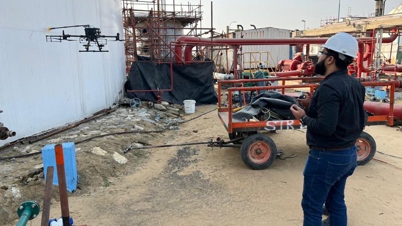 Pakistan Flying Labs inspecting an industrial plant
The Global South is no stranger to public health challenges, and GIS is vital in addressing them. GIS technology is used to map disease outbreaks, track the spread of illnesses, and optimize healthcare resource allocation during public health crises. These efforts are essential in controlling diseases and improving healthcare access.
Responding to the changing behavior of mosquito populations, which is making other techniques of combating malaria less and less effective, Madagascar Flying Labs is using GIS to map breeding sites and drones to spray organic insecticides. In Latin America, Peru Flying Labs delivered emergency medicine to indigenous communities in the remote areas of the Peruvian Amazon and, in the spirit of promoting the power of local, also trained local youth to do the same.
 Philippines Flying Labs preparing to deliver medical supplies to an area with impassable roads
Education is a powerful tool for change, and the Flying Labs Network recognizes this. Many Flying Labs have introduced GIS into their educational programs, engaging students in environmental studies. Teaching students how to create maps and analyze geospatial data fosters ecological awareness and equips the next generation with valuable skills for a sustainable future.
The Flying Labs Network proves the power of local expertise, resourcefulness, and innovation. It's not about importing solutions from afar but recognizing that the people closest to a problem often hold the key to its solution. The Flying Labs are not only demonstrating the capabilities of technology but also demonstrating the importance of fostering a culture of self-reliance and empowerment. Their work embodies the true spirit of GIS Day.
GIS technology continues to evolve, becoming more and more accessible and powerful. In the years to come, we can expect to see even more diverse applications. Despite the persistence of challenges such as climate change, natural disasters, and public health crises, it is uplifting to know that GIS professionals within the Flying Labs Network and beyond are up to the task—innovating, planning, and responding.
