
Breaking the Language Barrier: WeRobotics Partners with Beluga Linguistics...
April 23, 2024
With language localization, the Flying Labs Network will now step into a more interconnected and inclusive future.
August 8th, 2022

Nairobi is ranked as the world's 4th most congested city, with a potential cost of $1B per year and around 40% of total CO2 emissions- according to a 2019 report by Nairobi Metropolitan Area Transport Authority. Therefore, better monitoring of congestion is crucial to better understand its causes and facilitate more efficient operations and traffic management for complex multimodal dense urban environments like Nairobi. Nairobi has various monitoring techniques for congestion, e.g., loop detectors, GPS of different service vehicles, or cameras (like most cities worldwide). However, while these current tools advance in the direction of showing the symptom, they also systematically fail to find the root cause, let alone fix it. This makes estimating various performance measures for congestion and identifying the causes challenging for city officials and government agencies, such as the Kenyan Urban Roads Authorities (KURA) in Kenya.
Researchers of the Laboratory of Urban Transport Systems (LUTS) at EPFL (one of Switzerland's leading polytechnic universities) are introducing drones as a new monitoring tool that overcomes many current problems. "Drones provide excellent visibility, can cover large areas, and are relatively affordable. What's more, they offer greater precision than GPS technology and eliminate the behavioral biases that occur when people know they're being watched. And we use drones in a way that protects people's identities," says Manos Barmpounakis, a post-doc researcher at LUTS.
With the same goal in mind, creating innovative and sustainable solutions using drones, data, and AI to help solve development and humanitarian issues in Africa, Latin America, and Asia/Pacific, WeRobotics, LUTS, and Kenya Flying Labs have come together for a first joint experiment to test LUTS' innovative approach to traffic congestion, contributing to both SDG 9 (Industry, Innovation, and Infrastructure) as well as SDG 11 (Sustainable Cities and Communities). Additional partners of this first proof of concept in Nairobi in May 2022 were the Kenya Urban Rural Roads Authority (KURA) and Kenya's Presidential Delivery Unit (PDU).
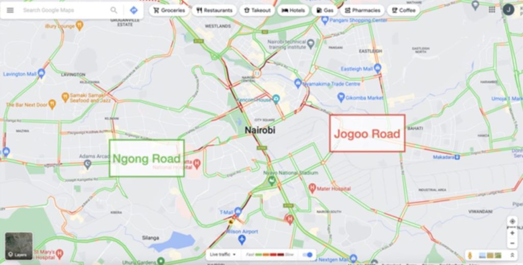
The proof of concept consisted of acquiring drone video data on two major roads within the Nairobi metropolis: Ngong and Jogoo. While LUTS has been leading in unique experiments with drone swarms for traffic monitoring, this was the first time a swarm of drones would fly over Nairobi. And operating drones in such a sensitive and complex urban environment involved important logistics, negotiations, and discussions to secure the flight permits, which was possible thanks to the critical local partnerships and close collaboration with PDU and KURA.
Kenya Flying Labs managed all operations and logistics locally, supported by WeRobotics' Drone and Data team for planning and technical and safety support. The swarm of drones of the experiment involved 5 drones on each road, so a total of 10 drones. This translated to bringing together a team of 10 certified drone pilots and supplementing each pilot with an assistant/spotter, so a team of 20 pilots and assistants. The 10 drones - a mix of DJI Phantom 4 Pro and Mavic 2 Pro - were coordinated to fly during the morning traffic peak hours (6:30 - 9am) and the evening traffic peak hours (4 - 6:30pm) over 4 days to meet EPFL's data requirement needs. In addition, Kenya Flying Labs' team coordinated with the traffic police on Jogoo and Ngong roads for smooth operations and the Moi Air Base control tower, which was always kept abreast of daily operations via mobile phone calls before and after each mission.
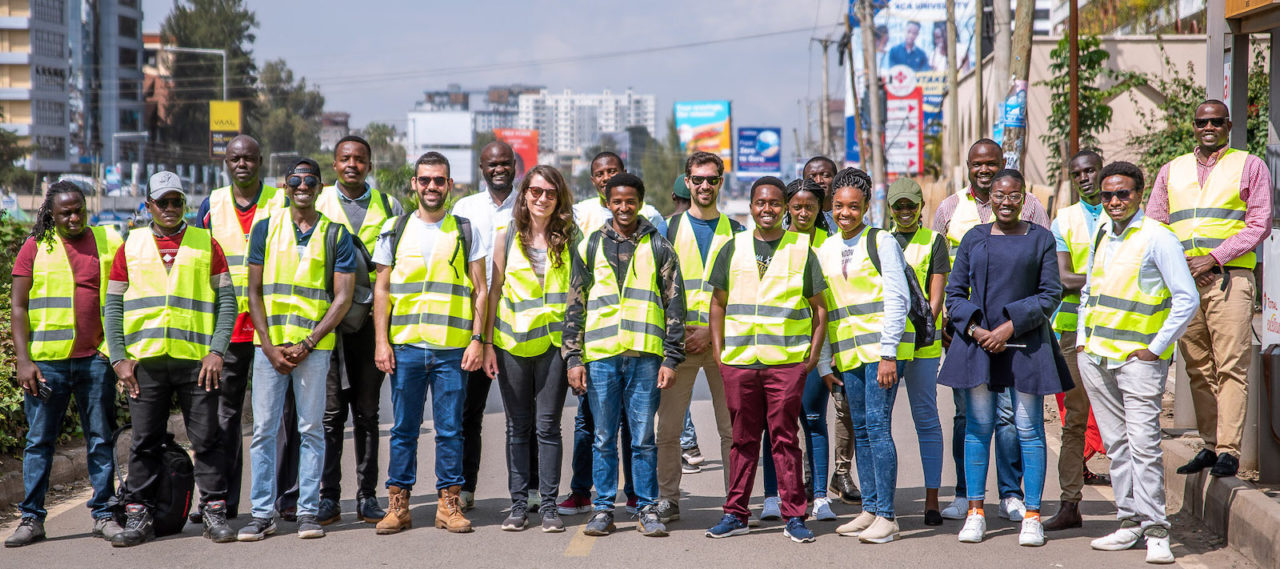 The most crucial challenge faced throughout the 4 days was the communication within the large team of pilots and assistants/spotters to align for simultaneous drone take-offs and ensure high data quality and consistency across the large group. Another challenge was the difficult conditions for the pilots and assistants/spotters due to the flight locations along major roads, such as road pollution, noise, and curious passers-by who needed to be reminded by the assistants/spotters to keep a safe distance. And naturally, all the logistics such as battery charging that comes with 10 drones and 5 consecutive flights twice a day. Teamwork, trust, and strong local leadership allowed us to overcome these challenges successfully.
The most important learnings made with this experiment were around the complexity of carrying out such operations in urban Nairobi and the effort required to secure the flight permits, organize the logistics, and successfully manage all the logistics. It became evident from the earliest moment that the key success factors to such a project are local knowledge and expertise mixed with the technical expertise of LUTS and WeRobotics, as well as a local network of contacts and partners. Another meaningful learning was the importance of multi-stakeholder collaboration to include all relevant stakeholders and their reservations, needs, and specific ideas in the experiment from the beginning to jointly learn from each other. Teamwork and strong local leadership were yet another important learning. The first outcomes already confirm that drones are a viable option for traffic monitoring, and with the data now in the hands of the EPFL LUTS team, we look forward to their analysis and outcomes in the coming months.
Throughout the 4 days, the team of 20 drone pilots and spotters managed to capture over 87 hours of video and over 4 TB of data.
