
Breaking the Language Barrier: WeRobotics Partners with Beluga Linguistics...
April 23, 2024
With language localization, the Flying Labs Network will now step into a more interconnected and inclusive future.
December 11th, 2020

Fast, accurate data processing and analysis are invaluable for Flying Labs using drone data for disaster response, environmental conservation, public health surveillance, and precision agriculture. While drones often receive much of the attention, software solutions are crucial to managing drone flights and improving data collection and analysis. That’s why we are excited to announce that SPH Engineering, the developer of UgCS software and integration services provider for drone systems, is now an official technology partner to WeRobotics and Flying Labs.
This year, SPH Engineering launched ATLAS—a drone data analysis AI-powered tool to store data, process aerial images, and share projects. ATLAS automates object detection on drone and satellite imagery to quickly and accurately identify and count objects of interest. SPH Engineering aims to increase drone surveying productivity and turn aerial photography into business insights with ATLAS.
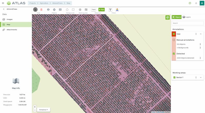 ATLAS in use for tree counting
Technology partnerships give Flying Labs access to robust technical solutions to benefit their social good projects. These partnerships also serve to transfer knowledge directly from leading industry experts and providers straight to Flying Labs, enabling the 30+ Flying Labs around the world to offer a growing range of locally-led services to their partners. SPH Engineering joins our existing partners to increase the Flying Labs’ tools for rapid imagery analysis.
Collecting and processing drone images is only a part of the work that Flying Labs lead. A vital part, but not the one that brings the most value. Partners like SPH Engineering allow Flying Labs to go the extra mile and turn their data into actionable insights. These insights reveal their work’s real value: enabling Flying Labs and their clients to make informed decisions based on data. As we know full well, converting data into action requires timely, accurate, and locally-led analysis.
Initially, ATLAS supported existing UgCS customers with an easy-to-use AI tool to store and process data collected with drones. Within six months of its launch, ATLAS’s AI-powered analytical capabilities to automate object detection in drone or satellite imagery have helped many other organisations detect, count, or measure the identified objects of interest. For example, ATLAS can locate defective road surfaces and identify complex shapes like field dodder weed or abandoned crab pots. SPH Engineering’s UgCS Industrial Solutions and Drone Show Software also assisted in such projects as archaeological investigation of Inca ruins in Peru and a recent drone show in the Philippines.
Ensuring that local experts with local knowledge are connected to a global community and have access to proper training in emerging drone technology is a shared priority for WeRobotics and SPH Engineering. SPH Engineering’s commitment to drone professionals ensures the leading drone mission-planning software, UgCS, and the AI platform ATLAS’s availability in local markets, including language support and training courses. The company’s continued support of academic studies by more than 40 universities spans environmental, archaeological, engineering, mining, agricultural, biological, and other applicable areas.
We are grateful to the team at SPH Engineering for joining us on our mission to multiply the Power of Local and providing Flying Labs with access to their software and support.
