
WeRobotics Partners with Elevate Africa UAS Summit 2024
April 30, 2024
WeRobotics is proud to be partnering with the Elevate Africa Summit to be held in Nairobi, Kenya in June 2024.
January 23rd, 2020

By Ónice Arango Flores, Unusual Solutions Finalist

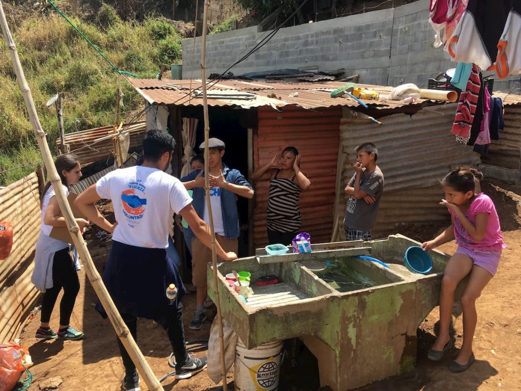
International nonprofit TECHO has registered over 317 informal settlements in the metropolitan area of Guatemala City. Left with no alternative, around 1.5 million in Guatemala live in makeshift houses with limited access to essential services such as running water, health care, electricity, or regular sewer networks. Additionally, 90 percent of settlements are located in highly dangerous areas like slopes and ravines. Residents living in these slums have higher rates of severe illness due to unsanitary living conditions, face higher levels of job loss and instability, and are disproportionally impacted by natural disasters, like floods and landslides (see Ciudad Peronia).
Traditionally, local government in Guatemala has not taken the knowledge of inhabitants into account, and whatever information is collected is not shared with the relevant communities. One negative impact of this practice is that planning proposals are executed based on assumptions and not with the particular context of the settlement, leading to small solutions and poor public policies. Additionally, this type of top-down urban planning makes it difficult for communities to take ownership of these plans and be conscious of the risks they face, diminishing their power of action.
At the moment, few up-to-date and comparable databases allow local government to know the specific risks associated with living in distinct informal settlements. Many civil society projects focusing on regional development have little impact on reducing these risks. As in most of the cases, they carry out small uncoordinated efforts, over-diagnosing vulnerable communities due to limited resources to carry out large scale interventions.
We see there is a considerable need to develop a participatory mapping tool for communities and local governments that will collect disaggregated and community-specific data. This tool will allow both local government and civil society to develop more effective solutions that respond to the specific set of risks faced by different settlements and areas. In the longer term, this data may also be instrumental in the development of housing and urban planning public policies. Furthermore, as this tool adopts a participatory approach, it will enable a more active role of communities in reducing the risks they face and designing their solutions.
Our dynamic solution employs the use of innovative tools such as drone images and mobile phone applications to allow NGOs and local governments to work closely with communities in mapping and identifying their risks collectively. We will also develop a platform to share all the verified and analyzed data; this information will be accessible to local government representatives, civil society organizations, and other actors interested in development. Through this solution, institutions will be able to connect with other stakeholders and access a set of support services to guarantee a qualified replication of the methodology in new contexts and the design of solutions for communities. Finally, we will also drive sufficient funding and finance mechanisms for community interventions. This platform will create an ecosystem that promotes knowledge sharing and collaboration between stakeholders working in risk management and climate change resilience at a national and regional level.
To reduce these challenges for people living in urban slums, we at Perpendicular, alongside the Observatorio del Derecho a la Vivienda, have developed a participatory methodology to identify communities’ risks and vulnerabilities. Based on the Sendai framework, our approach focuses on ensuring community participation in risk reduction strategies for more accurate urban planning that responds to real social needs. We are validating this approach with more than 14 institutions working on risk management in Guatemala. We have already run four successful pilot projects on informal settlements in Guatemala City, and approximately ten different experiments in communities in Mexico between 2016 and 2018. We have seen how this tool contributed to community empowerment and greater individual action. This experience was the starting point of a more complex and powerful idea that aims to develop a coordinated effort and boost the collaborative and systemic interventions to this highly-complex problem.
Now we want to scale-up our solution giving municipalities the power to develop a more interactive ecosystem for social development. Our next step is the design, development, and piloting of this platform with medium-sized cities, allowing us to prove and adapt our solution with institutions that can benefit more quickly from this data collection and then the potential development process.
Guatemala has historically not adapted innovative approaches for development, and, therefore, investing in this collaboration and ecosystem development will make one big step in innovative thinking. Our approach will enable not only territorial development but also start a transformation of institutions to be more inclusive, collaborative, and capable of designing culturally relevant solutions.
