
Breaking the Language Barrier: WeRobotics Partners with Beluga Linguistics...
April 23, 2024
With language localization, the Flying Labs Network will now step into a more interconnected and inclusive future.
October 26th, 2018

You’ve just collected another round of high resolution aerial images with your small drone. That was easy, took under an hour to collect a thousand images. Now what? You need to analyze these images to answer your questions and inform your decisions. For example, you need to count the number of damaged houses, healthy crops, water pumps, endangered animals or other features depending on your project. This is when things get difficult.
Research has shown that manually analyzing a single high resolution image can take a trained analyst a full minute. This means you now have to spend at least 10 hours to manually count features of interest in the areal images you’ve just collected. And tomorrow, you’ll be collecting another round of images. So you’ll need to spend another 10 hours to analyze them. FlyingLabs in Africa, Asia, Latin American and Oceania are facing this challenge on a daily basis.
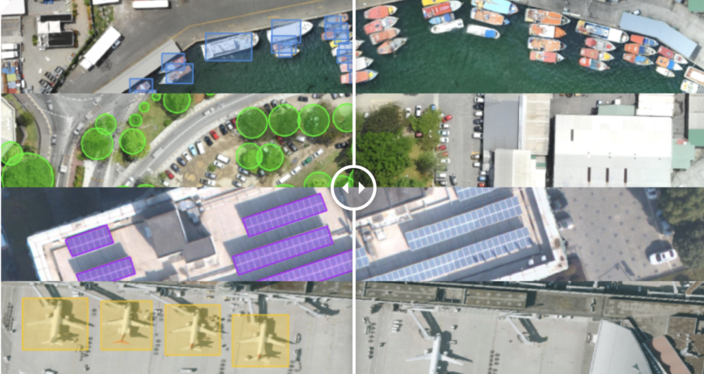
Enter our new partner, Picterra, a fellow Swiss start-up that combines aerial imagery, satellite imagery, deep learning and transfer learning to quickly help you automate the analysis of your imagery. What is particularly appealing to us about the web-based Picterra platform is that it is a self-service solution both in terms of generating training data and machine learning classifiers. As such, Picterra helps us to democratize the analysis of imagery through a simple point-and-click solution. What’s more, by combining deep learning and transfer learning, Picterra radically reduces the amount of training data needed to automate imagery analysis, making it remarkably faster than traditional solutions.
This explains why we’re excited to announce our formal partnership with Picterra, which makes their platform available to our global network of Flying Labs. The team at Picterra has already given a one-hour demo to Flying Labs around the world. What’s more, the team is also hosting the winning classifiers from our Open AI Challenges on the Picterra platform. In sum, our partnership with Picterra represents an important step forward for our Flying Labs as they expand their service offerings to include analytics and predictive analytics.
Picterra joins our growing network of technology partners, which already includes ESRI, Pix4D, DroneDeploy, DJI, senseFly, Parrot, OpenROV and others.
