
Breaking the Language Barrier: WeRobotics Partners with Beluga Linguistics...
April 23, 2024
With language localization, the Flying Labs Network will now step into a more interconnected and inclusive future.
October 9th, 2017

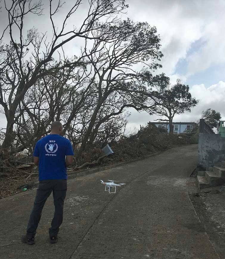
Angel Buitrago of the World Food Programme (WFP) stands beneath storm battered trees, near the shattered buildings of the Caribbean island of Dominica, guiding his DJI Phantom UAV into a bright afternoon sky. WFP is participating in assessment efforts to determine the impacts of Hurricanes Maria and Irma, estimated to have severely damaged or destroyed as much as 90% of Dominica’s built structures. UAVs slide under the cloud cover and capture high resolution imagery that will prove vital to recovery and rebuilding. But that only happens if operators like Angel can safely and efficiently get to where the imagery is most needed, in coordination with key stakeholders, and in such a way that data can be exported, uploaded, processed, shared and analyzed effectively.
As part of our ongoing collaboration with WFP to build coordination structures for UAV deployments in humanitarian operations, WeRobotics has been assisting with current humanitarian UAV coordination needs throughout the Caribbean. Without strong coordination teams may repeat each other’s work, make easily avoidable regulatory mistakes, or cloister crucial data rather than distributing and sharing it with those who need it to make better decisions. We’re attempting now to continue and deepen this effort in all affected islands and extend it to the enormous challenges of storm recovery in Puerto Rico.
For drone pilots and others with access to supply of technology we have created a working document which you can refer to here for extensive information about how to register your availability to participate in humanitarian UAV efforts for response and recovery, and how to utilize the tasking and coordination tools recently brought online by Open Aerial Map in order to identify areas of interest, claim them for tasking, and upload shared imagery for the broader humanitarian community.
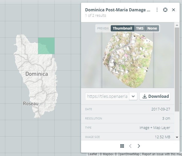
In some cases WeRobotics is also helping to process and share imagery on behalf of our partners in the field. Utilizing Esri’s Drone2Map we have processed imagery for the World Food Programme team in Dominica and aided them with Open Aerial Map uploads in order to bolster field capacity with remote resources. If other teams have need for imagery processing and other GIS services please contact Andrew Schroeder (Andrew@werobotics.org) and we will make every effort to augment your capacities.
Likewise, colleagues in the humanitarian community please contact us if you have imagery needs for specific locations, both in the immediate context and the continuing recovery effort. We will make every effort to link you with volunteers and others who may be able to assist. The best thing to do to expedite the process of fulfilling imagery needs is to follow the instructions in the linked document above to post your areas of interest into Open Aerial Map so that volunteer teams and others may see them and assign them for tasking.
Thanks so much to all of those who have done excellent work thus far in response to the relentless Atlantic hurricane season. Your efforts are essential, and will be even more so in the future. The movement to build efficient humanitarian UAV coordination efforts is ongoing and will require strong commitment from all of us to ensure that when we do bring our technical capacities to bear on aid to the most vulnerable we are doing so as efficiently, effectively and ethically as possible.
Join the conversation!
![]()
![]()
![]()
